
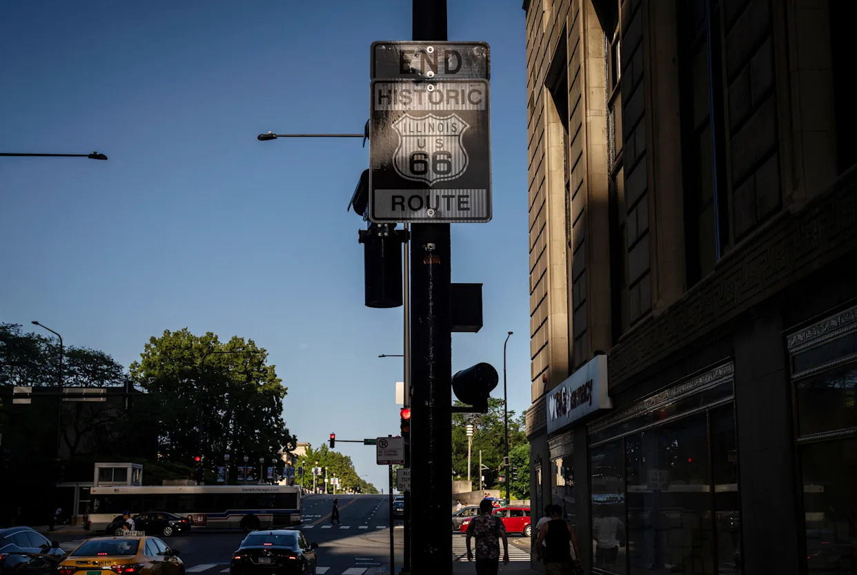
Our Route 66 road trip ended at the beginning, at East Jackson Boulevard and South Michigan Avenue in Chicago, where a brown sign hanging 12 feet high on a light post tells people they’ve reached the venerable road’s threshold.
On a hot and windy Saturday evening in June a large group of well-dressed people stood on the steps at the nearby Art Institute of Chicago, between the museum’s famed bronze lions and below a sign advertising an exhibit on Frida Kahlo’s time in Paris. Members of a mariachi band weaved through the crowd of pedestrians walking along Michigan.
Few people stopped at the Route 66 sign. Those that did, did not linger long. They pointed, noted its existence, and continued on their way.
AdvertisementAdvertisement#«R24ekkr8lb2m7nfblbH1» iframe AdvertisementAdvertisement#«R44ekkr8lb2m7nfblbH1» iframeWhile the route often conjures images of quaint small towns, its foundation, said historian and author Jim Hinckley, has always been rooted in Chicago. The existing roads and trails that would eventually become Route 66 nearly 100 years ago largely followed the railroad, with Chicago as its hub.
“Chicago’s part of Route 66 is a huge part of the Route 66 story,” Hinckley said. “It is a cornerstone.”
About 300 miles southwest of Chicago, different alignments of the route leave St. Louis and cross the Mississippi at three different bridges. The northernmost iteration once spanned the river at the milelong Chain of Rock Bridge. Constructed three years after the route was commissioned, the bridge makes a 30-degree turn at its midpoint between St. Louis and Madison, Illinois.
The bridge closed in 1968, replaced by a new one 2,000 feet upstream. Today, the original structure carries pedestrians, cyclists and, on a Thursday in June, one dog.
AdvertisementAdvertisement#«R29ekkr8lb2m7nfblbH1» iframe AdvertisementAdvertisement#«R49ekkr8lb2m7nfblbH1» iframeThe road climbs north toward Springfield, where a former Texaco gas station from 1946 a block from the route now houses the Route History Museum, which documents the Black experience on Route 66.
Public health researchers by trade, museum founders Gina Lathan and Stacy Grundy spent more than a year collecting stories of Black homeowners and business owners — some found in The Negro Motorist Green Book — who provided safe havens along the route at a time when vast stretches of the highway passed through sundown towns.
Museum visitors are given virtual reality headsets to help bring those stories to life.
“They want to be a part of the story of Route 66,” Lathan said of the families she and Grundy interviewed, “and be recognized for not only what their family and the community brought to that whole travel experience, but what they as a people did to not only persevere but make these phenomenal economic engines in these communities that were oftentimes forgotten.”
AdvertisementAdvertisement#«R2eekkr8lb2m7nfblbH1» iframe AdvertisementAdvertisement#«R4eekkr8lb2m7nfblbH1» iframeContinuing north, stretches of the route lie nestled between Interstate 55 and farmlands. In Atlanta, population 1,637, a group of international journalists and media buyers from at least a dozen countries snapped photos of towering “muffler man” fiberglass statues — once used to advertise businesses along the route — collected at the town’s American Giants museum.
The group trip, organized by the state’s tourism office, followed the International Pow Wow (IPW) travel trade show in Chicago. Illinois has invested millions over the last few years on Route 66 redevelopment and promotion, said Eric Wagner with the state tourism office.
“Route 66 is huge for us,” he said. “People want to see America.”
Follow our road trip: Route 66, ‘The Main Street of America,’ turns 100
About 50 miles north, Pontiac also appears to have capitalized on its position along the route. Among its attractions is the Route 66 Association Hall of Fame & Museum. There, visitors can find a school bus-turned-land yacht and a Volkswagen van belonging to Bob Waldmire, whose family opened the Springfield, Illinois, institution Cozy Dog on Route 66 and claims to have invented the corn dog.
AdvertisementAdvertisement#«R2lekkr8lb2m7nfblbH1» iframe AdvertisementAdvertisement#«R4lekkr8lb2m7nfblbH1» iframeWaldmire became a legendary figure of the route’s lore with his hand-drawn postcards, maps and murals. Both he and the van he took on his frequent route trips served as the inspiration for the character Fillmore in the Disney Pixar film “Cars.”
Waldmire died in 2009 of cancer, before he could finish painting a map of the Route 66 stretch through Illinois on a wall of the museum.
“He was very friendly, that’s why he never got the mural done,” said Rose Geralds, 87, who has worked at the museum for the last 18 years. “He stopped and talked to everybody. He didn’t care. He just wanted to talk to the people. Just such a nice man.”
Forty miles north, artist Robert Ryan, 61, stopped to inspect a detail in the mural he’s painting on a storage building along Route 66 in Wilmington’s South Island Park, next to the town’s famed Gemini Giant, a 30-foot-tall fiberglass “muffler man” recently relocated to the park after once facing destruction.
AdvertisementAdvertisement#«R2qekkr8lb2m7nfblbH1» iframe AdvertisementAdvertisement#«R4qekkr8lb2m7nfblbH1» iframeRyan’s design, picked out of 20 or so entries, covers three walls of the building. One side shows a large Route 66 shield behind a yellow convertible driven by the original owners of the Launching Pad restaurant where the Gemini Giant once stood. Nearby, the town’s football team waves to viewers.
A mural on another wall has the giant standing in front of an American flag and behind the town name painted in block letters. A third wall mural depicts motorcyclists on the route.
“The best part has been talking to people who stop to ask about it,” Ryan said.
Leaving Wilmington, the route heads past farmlands now broken up by massive logistic centers amassed on the outskirts of Joliet, where the country’s largest inland port is located. It cuts through Joliet’s downtown, past Stateville Correctional Center and into Romeoville and Bolingbrook. It’s briefly absorbed by I-55 before returning as Joliet Road.
AdvertisementAdvertisement#«R2vekkr8lb2m7nfblbH1» iframe AdvertisementAdvertisement#«R4vekkr8lb2m7nfblbH1» iframeNear Hodgkins, the route is forced to detour around a quarry where a stretch of the road has been closed for decades. It links up with Ogden Avenue in Berwyn and takes motorists through Cicero and into Chicago, through North Lawndale, Douglass Park and across the Eisenhower Expressway, named for the president who commissioned the interstate highway system that led to its demise.
Route 66 then hits Jackson Boulevard and runs to its eastbound end.
A block north of Jackson, a similar brown sign on a light post at Adams Street and Michigan marks the start of Route 66 for those heading west.
At 8 a.m. on Sunday in June a family of three stopped to pose for pictures in front of the sign. This was not the start of their journey but, rather, a seemingly good photo opportunity.
AdvertisementAdvertisement#«R34ekkr8lb2m7nfblbH1» iframe AdvertisementAdvertisement#«R54ekkr8lb2m7nfblbH1» iframeBut a mile west at the unofficial start of the route, the 102-year-old Lou Mitchell’s diner, Eleonora Tomassetti and Chiara Voceri took the last bites of a pancake before heading to pick up their rental car.
Originally from Rome, the pair, both 27, first got the idea for a Route 66 road trip in high school. Earlier this year, they decided to turn that idea into a reality.
They planned a two-week trip: Stops in Joliet, Atlanta and Springfield. An overnight stay in St. Louis. Another in Tulsa, Oklahoma and in Tucumcari, New Mexico. Two nights in Albuquerque, New Mexico. Stops in Winslow and Flagstaff, both in Arizona. Detours to the Grand Canyon and Las Vegas.
Said Tomassetti: “I think it’s the perfect example of the American adventure.”